Tropospheric propagation is radio propagation that occurs in the lowest
layer of the Earth's atmosphere - the troposphere. It is 100% weather-related. A
Tropo DX mode is
any abnormal condition
that scatters, reflects or refracts VHF, UHF and/or microwave signals in
the troposphere causing changes to their normal coverage. Another name
for this is anomalous propagation, or AP for short. Tall mountain
ranges form a physical barrier to tropospheric propagation, thus tropo
is more rare in or across mountainous regions. Deserts are usually too
dry to support the long distance tropospheric modes. There are six main
tropospheric DX modes. The refraction and ducting effects are similar to
those that cause visual mirages. Therefore, the distant signals
received via tropo can be considered "radio mirages". Signals that are
normally below the radio horizon and out-of-range instead appear above
the radio horizon and receivable. (Note that due to the difference in
wavelengths, the radio horizon is farther away than the visual horizon).
A description of the tropo modes follows:
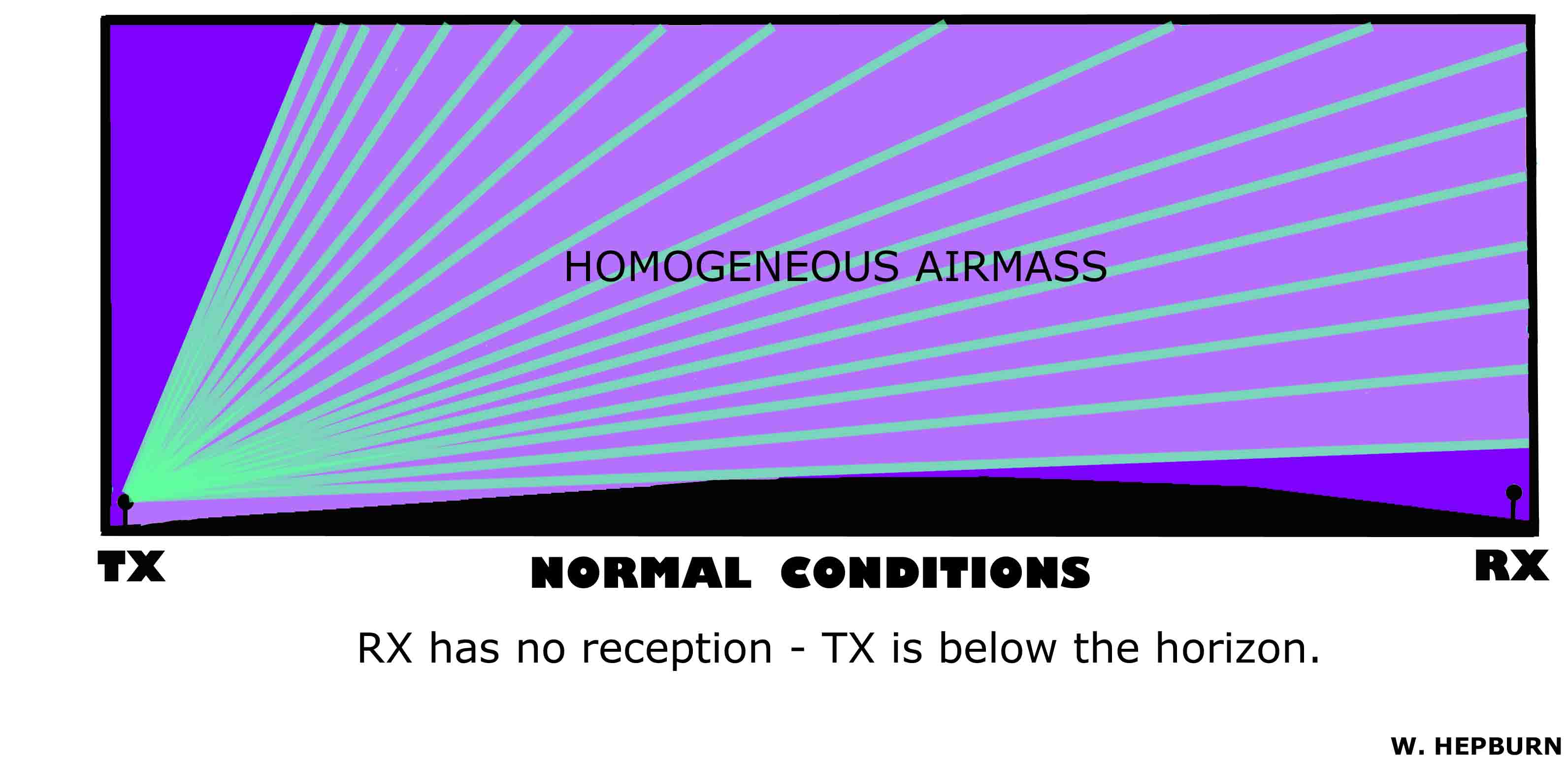
1) LINE-OF-SIGHT (GW)
- Also known as Groundwave. Normal steady continuous reception where the
receiving and transmitting antennas can see each other, taking into
account the 4/3 Earth curvature of radio waves. Figure 1 illustrates
normal conditions where the receiver is out-of-range. The illustration
is not-to-scale.
2) TROPOSPHERIC SCATTER (TrS)
- An almost ever-present condition that brings in distant fluttery
signals beyond normal line-of-sight. Scattering of the signals occurs in
contact with discontinuities in the troposphere. These discontinuities
can be small temperature or humidity variations, such as those that can be found
around cloud layers, individual clouds, updrafts, downdrafts, small droplets such as drizzle and mist, or they can be large,
such as the
tropopause (the boundary between the troposphere and the stratosphere).
The tropopause provides most of the longer-distance scatter due to its
extreme height above the ground.
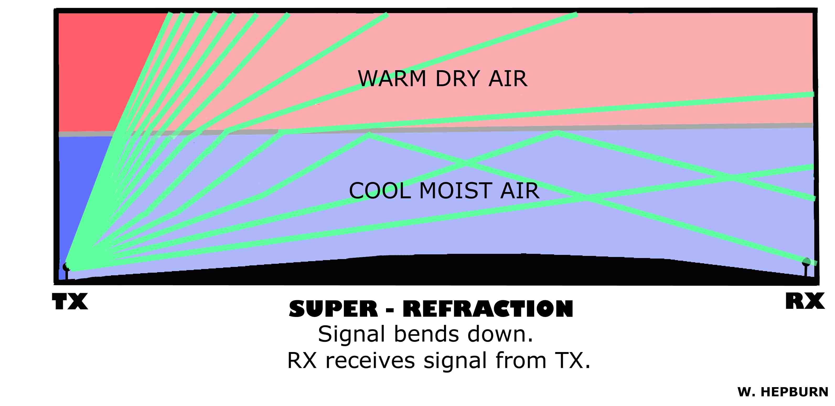
3) TROPOSPHERIC SUPER-REFRACTION (TrE)
- Also known as Tropospheric Enhancement or Tropospheric Bending.
Super-refraction occurs when the lower troposphere becomes stratified
into two stable layers. A warm dry layer over a cool moist layer (with
warm and cool
being relative terms). This setup is called
an inversion. Normally in the lower troposphere, temperatures decrease
with height and humidity increases with height
- thus why they are called inversions. Signals bend as they cross the
inversion. When they start bending downwards, the signals can travel
farther, reaching places that are normally beyond the radio horizon and
out-of-range. The effective bending is now less than 4/3 Earth
radius, but still more than 1 Earth radius. The base of the inversion
is considered to be the ground. The top of the inversion is the airmass
boundary. Figure 2 illustrates
super-refraction.
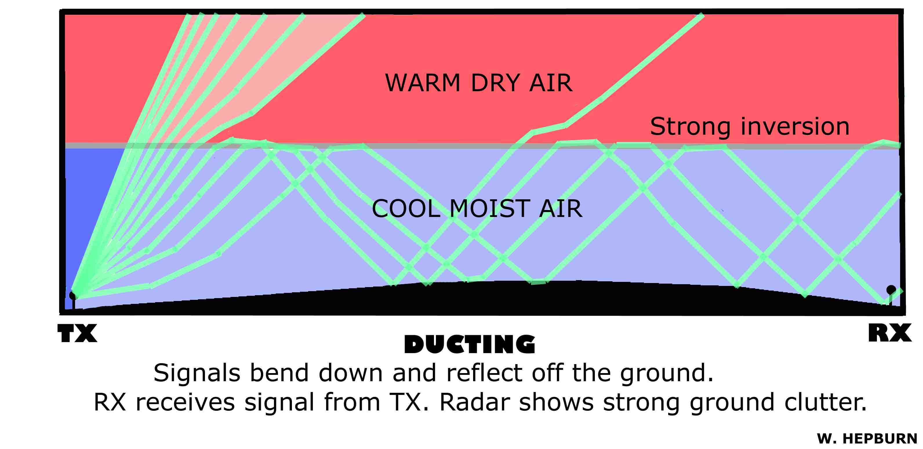
4) TROPOSPHERIC DUCTING (TrD)
- Ducting occurs when the super-refractive bending becomes so much that
the signal hits the ground at a distance far away from the
transmitter - and is then reflected back up to the inversion, to then be
refracted back down again. In essence, the signals become trapped in a
"trapping layer" or duct. The effective bending is now less than 1 Earth radius. The
base of the duct is the ground. The top of
the duct is the airmass boundary. Signals do weaken when reflecting off the
ground. Signals that reflect off of a water surface instead (ocean/lake)
retain much more strength. One side-effect of ducting is reduced range
for aircraft flying above the inversion. Most ducting occurs below 3000 m
(10,000'). Above that level, the air starts to get too sparse in
density for inversions to be strong enough. The thickness of the duct (which equals the height of the inversion for a surface-based duct) can roughly determine the
lowest usable (affected) frequency (LUF). Figure 3 illustrates
ducting.
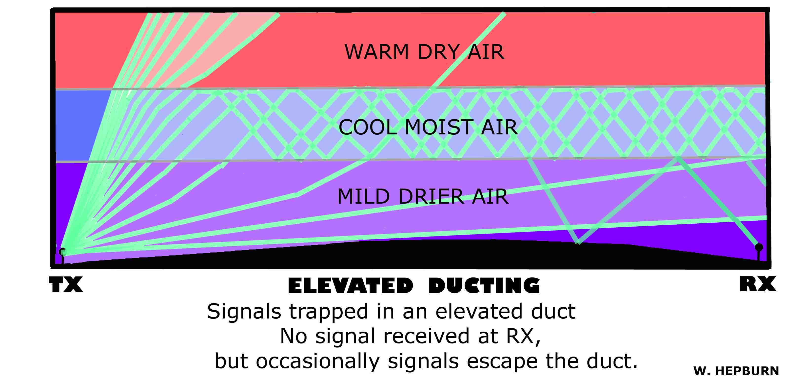
5) ELEVATED TROPOSPHERIC DUCTING - In
cases where the top of the inversion is very high above the ground, it
may become possible for the low level moisture to rise and pool beneath
the inversion top. In these cases, 3 different airmass layers can form -
with the surface layer being somewhat warmer and drier than the cool
moist air higher up. This results in a duct that is elevated above the
ground. Although the signals are being carried far from the transmitter,
receivers at low elevation will not be able to receive them. Only tall
masts or locations on high hills that "poke" into the duct will be able
to receive the signals. Often this is the case with the transmitter as
well, as tall masts or locations on high hills poking into the duct get
direct access to it. Although the bulk of the trapped signals stay
within the duct, they may occasionally escape allowing for random and
spotty reception beneath the duct. Often, long ducts may consist of
portions that are surface-based and portions that are elevated. An
elevated duct that reaches the surface on both ends can result in
distant reception without anything else in-between being received. These
ducts are nicknamed "tropo wormholes" as they act like a wormhole from
the sci-fi's. Figure 4
illustrates elevated
ducting.
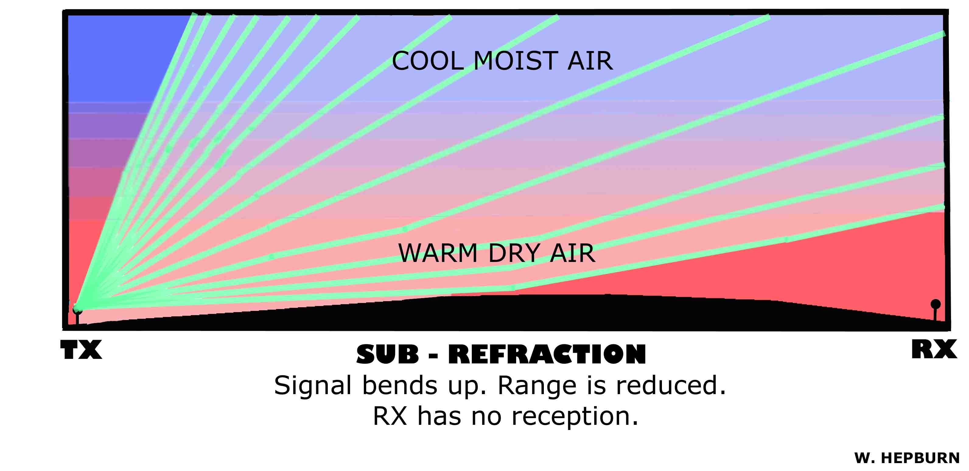
6) TROPOSPHERIC SUB-REFRACTION (-Tr) - Also known colloquially as "Anti-Tropo". Sub-refraction occurs when
the lower troposphere becomes unstable with a greater-than-normal
dropoff of temperature with height. Signals gradually bend upwards. The
effective bending is greater than the normal 4/3 Earth radius. This
results in reduced range for all signals. The degree of abnormal bending
during an extreme sub-refraction event is much less than that observed
during extreme super-refraction. Figure 5 illustrates
sub-refraction.